Geology of the Leeds District
Geology of the Leeds District
All of the rocks that can be seen at outcrop in the Leeds district were formed between 325 and 253 million years ago (Ma) during the Carboniferous and Permian Periods of geological time (Figure 1) and are sedimentary in nature. Earth movements have disrupted the original horizontal layers so many now lie tilted, folded and broken by faulting.

Figure 1 – The Geological Time Scale
Rocks of Carboniferous age, represented by the Millstone Grit Group and the Coal Measures Group, make up most of the district and largely consist of layers of sandstone and mudstone that generally dip at shallow angles towards the south.
The eastern part of the district is made of rocks of Permian and Triassic age, the predominant rocks are limestones and sandstones that dip at low angles towards the east.
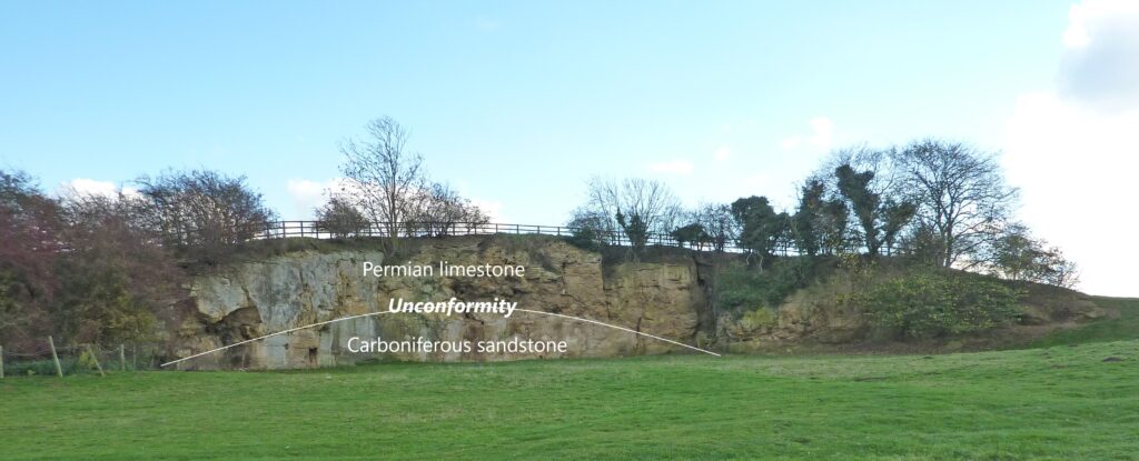
Where rocks of Permian age overlie Carboniferous ones there is a difference in age of around 30 Ma between them. This type of boundary is called an unconformity (Figure 2) and indicates a break in the geological record caused by the Carboniferous rocks being uplifted and eroded before subsiding and the Permian rocks deposited on top.

Figure 2 – Permo-Carboniferous Unconformity. Newsome Bridge, Nr Wetherby
Rocks younger than Permian were deposited over the whole area but these have been removed by erosion following subsequent episodes of uplift of the land.
Mantling the whole district is a variable thickness of soft sediments that have been deposited over the past 2.5 Ma during the Quaternary Period, by the action of melting ice, rivers or in lakes.
Carboniferous Period
Millstone Grit Group
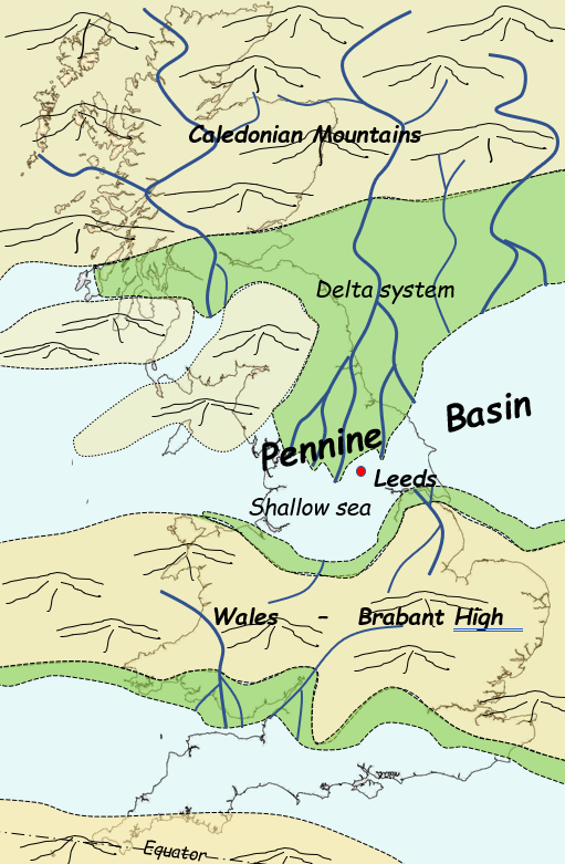
326 Ma the district lay in equatorial regions beneath a shallow sea, in an area where the earth’s crust, due to being stretched, was steadily subsiding, forming what is called the Pennine Basin (Figure 3).

Figure 3 – The Pennine Basin
To the north, across what is now Greenland, Scotland and Scandinavia, stood a mountain range of Himalayan proportions from which giant rivers flowed. Sand, silt and mud, eroded from the mountains, was carried south by the rivers before being deposited when they slowed down on entering the shallow sea. Over 13 Ma this created a vast network of deltas which spread slowly southwards, eventually filling the basin.
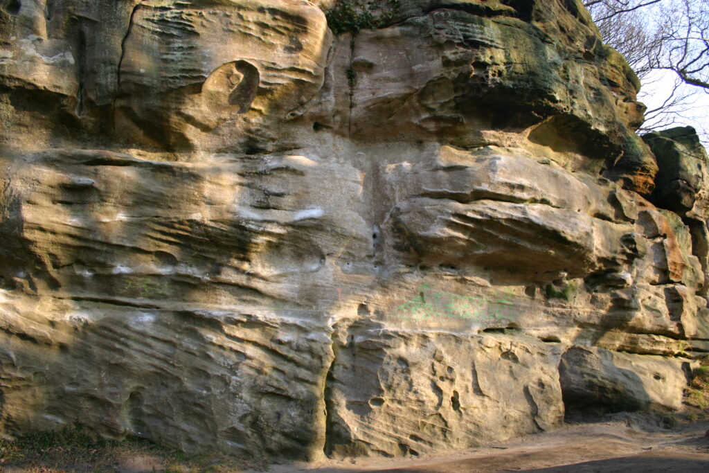
Deltaic environments are extremely varied resulting in a range of different types of sediment being deposited in different places at the same. In main river channels, which could be up to 1 km wide and 40 m deep, water flowed fastest, and coarse sand and gravel was deposited as sandbars and large underwater dunes, identifiable today by a distinctive current bedding pattern. (Figure 4).

Figure 4 – Current-bedding in the East Carlton Grit. Hetchell Crags
Finer grained sand was deposited in channels where currents were slower, and on land adjacent to river channels during flood conditions. Mud and silt were deposited in the backwaters, swamps and temporary lakes that formed on the delta tops after flooding. These were inhabited by freshwater animals whereas types that could tolerate brackish water occupied the estuaries and lagoons where the rivers met the sea. Mud deposited in these lakes and lagoons is usually dark in colour due to the high levels of carbon it contains. This came from undecomposed organic matter showing that the waters in the lake bottoms were deficient in oxygen. In the hot, wet climate vegetation grew rapidly on the swampy delta tops and, where it existed for long enough, peat bogs developed. Because the river channels were constantly shifting, the size and shape of the bodies of the different types of sediment varied greatly in thickness and lateral extent.
Periodic melting of the ice cap that covered much of the southern continents at this time, as well as continued but erratic subsidence of the basin, caused repeated sharp rises in sea levels which flooded large areas of the delta and resulted in deposits of marine mud. As ice caps reformed and sea levels fell, deltaic environments returned as the shallow seas were filled with new layers of sediments in non-marine environments. Bivalves and goniatites are good indicators of these changing environments.
Continued subsidence of the basin allowed over 1700 m of sands, silt, mud and peat bog to accumulate across the district which, over time, become compressed and cemented to form gritstone, sandstone, siltstone, mudstone, and shale for the remains of the plants and animals they contained to be preserved as fossils.
Coal Measures Group
By 313 Ma the Millstone Grit deltas had spread south into the north Midlands and the mountains to the north had become much reduced by erosion. The district was now part of a broad coastal plain crossed by wide, slow moving, meandering rivers. The rate of subsidence of the Pennine Basin had slowed and forests that colonised the plain became more extensive and long lasting with thick layers of peat forming in the low-lying, poorly drained conditions. The slow flowing rivers still carried large amounts of sediment, some of which was deposited on their beds and banks creating natural embankments (levees), that raised the rivers above the forest floor. Bursting levees during floods, or by erosion, resulted in areas of forest being flooded and replaced by shallow lakes which slowly filled with sediment allowing the forest to be re-established.
Slow subsidence of the coastal plain coupled with changes in directions of river channels, sediment supply and marine inundations caused by rapid rises in global sea from melting ice caps, resulted in a distinctive pattern of sediments being deposited known as Cyclothems (Figure 5).

Figure 5 – A typical Coal Measure Cyclothem
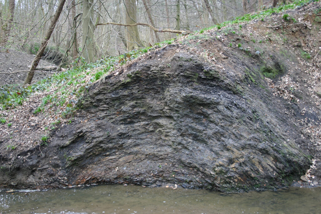
These show a cyclic pattern as the plains were repeatedly flooded then buried in sediment and forests re-established. A typical cyclothem begins with dark grey mudstones which are often rich in fossil plant material, especially leaves. That the sea periodically inundated wide areas of the coastal plains is shown by ‘marine bands’, identifiable by their fossils, that occur in the mudstones of some cyclothems. Many of the mudstones contain thin layers or hard, isolated masses called nodules, of iron minerals. These were formed by complex chemical reactions acting on the products of partial decomposition of organic material, soon after the sediment was deposited. Mudstones pass upwards into grey, ripple-marked siltstones (Figure 6) which again are often rich in plant debris.

Figure 6 – Ripple marked siltstone. Garforth
Siltstone grades up into fine to medium grained, grey sandstone which often turns yellowish brown on exposure to air due to its iron content. They commonly contain fossilised plant stems and roots of the vegetation that grew on them (Figure 7) and trace fossils of organisms that burrowed through them.

Figure 7 – Fossil tree roots. Lister Park. Bradford
The thickness and nature of sandstones vary across the district between 0-50 m, with their individual beds ranging from being only a few centimetres thick to over 1 metre. Where beds are thin, parallel and have a coating of the mineral mica, the rock splits easily into thin slabs and is known as flagstone. Seat earths (fossil soils) (Figure 8) containing roots frequently occur on top of the sandstones and indicate that the lakes had filled with sediment, soils formed, and vegetation returned. Gannisters are seat earths that developed on sand, fireclays are ones that developed on mud. Coal seams, formed from the undecomposed remains of forests that grew on the swampy plains, frequently occur above the seat earths and are the last rock in the cycle.

Figure 8 – Coal seam and seat earth. Beeston. Leeds
There are 30 named coal seams in the district with thicknesses varying from 0.1 – 4.3m, the differences depending on local rates of accumulation, subsidence, and length of time the forest existed. Continued subsidence of the Pennine Basin allowed 1250 m of these cyclic deposits to accumulate in the Leeds district.
Earth Movements
Throughout the Carboniferous Period the earth’s crust under what was to eventually become the British Isles, was being affected by earth movements caused by shifting of crustal plates. These reached a peak at the end of the Carboniferous Period 290 Ma when compressive forces caused the rocks deposited in the Pennine Basin to be tilted, folded, broken (faulted) and uplifted. This was part of much more intense activity in what is now southern Europe where mountain ranges were forced up and is known as the Variscan Orogeny (Figure 9).

Figure 9 – The effects of the Variscan Orogeny
The Carboniferous rocks slowly began to rise and be transformed into low hills where, across the higher parts, the agents of erosion began to strip away Coal Measures rocks, exposing the older, Millstone Grit Group rocks, that lay below.
Many earthquakes would have been generated as the rocks buckled and broke and the resulting folds (Figure 10) and faults (Figure 11) vary in scale from centimetres to kilometres.

Figure 10 – Small folds in Millstone Grit Group shales. Roundhay Park. Leeds

Figure 11 – Small faults in the Rough Rock gritstone. Roundhay Park. Leeds
The Roundhay Park Fault brings Coal Measure Group rocks alongside Millstone Grit Group rocks, a vertical displacement of approximately 180 m, and runs for many kilometres. Large faults like this resulted from repeated movement over long periods of time.
Permian Period
By 300 Ma ‘Britain’ had drifted northwards to lie 150 – 250 north of the equator, the same as today’s Sahara Desert, and was experiencing a hot, arid climate. For approximately 30 Ma the land raised by earth movements was subjected to prolonged subaerial weathering and erosion. Little sediment was deposited in the area, but instead, in places, 1- 2 km thickness of rock was removed. Areas underlain by the resistant sandstones of the Millstone Grit Group were reduced to gently undulating hills while those underlain by softer Coal Measure Group rocks were worn down to a rolling peneplain, sloping gently to the east. The Leeds district straddled the boundary between these two environments.
270 Ma the earth’s crust started to subside creating a large basin that stretched from ‘Britain’ into northern Europe, with the Leeds district situated on its western margin, and sediment started to be deposited in hollows and local depressions on its gently undulating, desert surface. This was sand, which accumulated in patches of variable thickness having been blown by the wind or deposited by temporary rivers during sporadic, torrential rainstorms. The sands were very pure, had distinctive round grains of similar sizes and were often deposited as dunes. When exposed at the surface today they show as bright yellow, desert sandstones with distinctive cross-bedding (Figure 12) and rest unconformably on the older Carboniferous rocks

Figure 12 – Dune bedded, Permian sandstone (Yellow Sands Formation). Holywell Wood, Glasshoughton
A dramatic change occurred when the margin of the basin (which had now sunk below sea level) and an open ocean to the north, was breached, and the whole area was rapidly flooded, creating an almost landlocked body of water known as the Zechstein Sea. (Figure 13).

Figure 13 – The Zechstein Sea
The deepest parts of this were around 200-300 m but as the Leeds district lay on the western margin, here depths varied from 0 – 15 m. With little sediment being worn off the surrounding, low-lying land, the main sediment in the warm, shallow sea was of the mineral calcite (calcium carbonate – CaCO3) which had two sources. One was organic, being the shells, skeletons and supports of animals that lived in the sea, while the other was as a chemical precipitate, direct from the seawater. The hot, arid climate led to high rates of evaporation and an increase in salinity of the seawater. CaCO3 is the least soluble salt in sea water and so the first to precipitate when salinity increases resulting in deposits of fine, calcite mud which, along with the shell debris, formed limestone. In places reef structures and microbial mats are preserved, along with a sparse fauna of shelled animals that include bivalves. Percolation of more saline waters into these limestones initiated chemical reactions which resulted in much of the original calcite being converted to the double carbonate, dolomite CaMg(CO3)2 creating the creamy yellow dolomitic limestones seen today, and which are the youngest rocks visible at the surface in the Leeds district.
Triassic Period
By the end of the Permian Period the shallow Zechstein Sea had evaporated, and the eastern part of the district become a flat plain, crossed by a network of braided river channels. These were fed by rivers flowing from uplands to the south and deposited layers of sands and muds when they flooded. There are no local exposures of the soft sandstones the sediments became, but they are known from boreholes drilled to extract the water they contain. The rocks are a strong red colour which is indicative of deposition under or warm, humid (probably monsoonal) climate.
Quaternary Period
By 2.5 Ma the British Isles had drifted to its present-day latitudes and, after a long period of cooling, the earth’s climate had reached icehouse conditions when permanent ice caps existed at the poles. Since then, climate has fluctuated between periods of cooling, when ice cover expanded (glacials) and periods of warming, when ice cover shrank (interglacials), which is the state that exists today. Situated in the north of the temperate zone these fluctuations, which have happened approximately 50 times, affected Britain dramatically but it is only for the more recent episodes that clear evidence exists as each new glacial event removed much of the evidence of the previous one.
The oldest glacial event for which evidence is preserved in the Leeds district occurred 470-410 Ka and is known as the Anglian Glaciation. This was a period of intense cold when an ice sheet, probably over 1km thick, spread across the whole district. As the ice melted it deposited the material it had eroded from the land it had travelled over. This consists of a mixture of rock and mineral fragments ranging from sand grain size up to boulders (Figure 14), all set in a matrix of clay composed of finely ground ‘rock flour’ and is called till. The blanket of till is called moraine but being unconsolidated much has been removed by subsequent erosion. Patches of it left by this glaciation still occur in places unaffected by later ice advances and the boulders it contains indicate the direction that the ice that carried them travelled in.

Figure 14 – The ‘Castle’ in Roundhay Park. Built of blocks of gritstone carried here by ice from Addingham Edge on Ilkley Moor during the Anglian Glaciation 400 Ka.
It is known from other parts of the UK that the Anglian event was followed by the Hoxnian interglacial and Woolstonian cold period, but nothing is known of their effects of in the Leeds district as no evidence remains.
More is known of the Ipswichian interglacial, which lasted between 128-116 ka, when the climate was warmer than it is today. One of the best pieces of evidence for this was the discovery of hippopotamus, (‘The Leeds Hippo’) elephant and auroch (wild ox) bones in a brick pit that had been dug in lake deposits in Wortley in 1851.
The most recent glacial, the Devensian, began 116 Ka, had its period of maximum ice 27 ka and only ended 11.5 Ka, so evidence of it is much fresher. During the Devensian, ice that had originated in the Lake District and Western Pennines, moved into the district from the west as glaciers along the valleys of the River Aire and Wharfe, reaching as far as Apperley Bridge in the Aire valley and Pool in the Wharfe valley

Figure 15 – A valley deepened, widened, and straightened by glaciers. Wharfe Valley. Otley.
The Wharfe and Aire valleys were deepened and widened (Figure 15) by the erosive power of the glaciers, but higher land, and that beyond the ice front, remained as a frozen tundra. As the ice melted it left behind a covering of till as well as sands and gravels deposited from meltwaters.
