Geology and Scenery
Geology and Scenery
The varied nature of the underlying rocks, their structure and the geological processes that have sculpted them have produced the topography seen today across the Leeds district.
Rock type and Structure
The areas underlain by rocks of the Millstone Grit Group form the highest land. This is because the thick beds of hard, coarse sandstone the Group contains are the most resistant to weathering and erosion. The layers of sandstone and their intervening mudstone generally slope (dip) to the south. The differences in resistance to erosion between the hard sandstones and weaker mudstones has resulted in a series of east-west sandstone ridges separated by areas of lower land.
The Coal Measure Group rocks generally form lower land because easily eroded mudstone makes up a greater proportion of their total thickness. Areas of higher ground within the Coal Measure Group rocks usually corresponds to outcrops of more resistant sandstone.
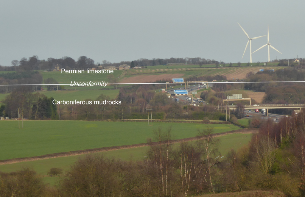
Permian limestones dip gently to the east and, due to them being resistant to erosion, they form a prominent west facing scarp slope (Figure 1). This has been worn back over time leaving several hills, capped by limestone, isolated from the main outcrop (called outliers).

Figure 1 – West facing scarp slope formed where the hard, Permian age dolomitic limestones overlie soft, Carboniferous mudrocks, M1, Garforth
Sudden changes in the landscape occur in some places where faulting has caused rocks with different resistances to weathering and erosion to be moved adjacent to each other.
Geological Processes
While the rocks in the Leeds area were formed hundreds of million years ago the scenery has been formed over the past 2.5 million years during the Quaternary. During this time the climate has oscillated between periods extreme cold (glacials) which saw ice cover or tundra conditions affecting the area, and periods of warming (interglacials) when temperate and even sub-tropical conditions prevailed. It is the glacial periods that have had the greatest effect on topography. As the last glacial period, known as the Devensian, only ended 11,500 years ago the evidence of it is still fresh. Ice is an extremely effective agent of erosion, transport and deposition. As ice advances it erodes the rock it moves over and can transport it great distances. When ice melts it deposits the load of eroded rock, which consists of rock fragments ranging in size from tiny particles to huge boulders known as till, as a blanket of variable thickness known as moraine.
During the Devensian, ice from the Lake District and western Pennines moved into the Leeds district as glaciers along the valleys of the river Wharfe and Aire. Its effect was to deepen, widen and straighten the valleys, carrying away vast quantities of rock. In places oversteepening of valley sides has resulted in large landslips occurring when supporting ice melted away (Figure 2). These are a particular feature of the south side of the Wharfe valley beneath Otley Chevin and Ilkley Moor and some are still moving today.

Figure 2 – Rocky Valley, Ilkley Moor. Formed by a landslip on slopes over steepened by glaciation
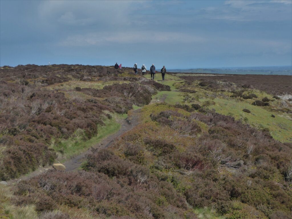
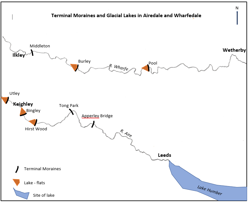
Where the rate of melting of the glacier was equal to that of its advance the fronts of the glacier became stationary and debris was deposited, building a low ridge of debris known as a terminal moraine. This occurred at Poole in the Wharfe valley and Apperley Bridge in the Aire valley where these low ridges can still be seen. As the climate warmed the glacier fronts ‘retreated’ only to become stationary again during brief periods of cooling. This resulted in a series of terminal moraines being formed in each valley, marking the glaciers’ retreat. Moraine was also deposited at the edges of glaciers forming low ridges parallel to the valley sides. Lanshaw Delves (Figure 3), high on Ilkley Moor and nearly 300m above the present-day valley floor, indicates the thickness of the Wharfedale glacier at this point.

Figure 3 – Lanshaw Delves, Ilkley Moor. A lateral moraine formed at the edge of the Wharfe Glacier
Melting ice released vast amounts of water forming rivers much bigger and more powerful than the ones occupying the valleys today. These carried away much of the till, before depositing it as sands and gravels along their channels, and as silts and clays in temporary lakes formed in hollows in the valley floors or trapped behind the terminal moraines. A succession of terminal moraines with infilled lakes are recognisable in the Wharfe and Aire valleys (Figure 4).

Figure 4 – Terminal moraines and glacial lakes in Airedale and Wharfedale
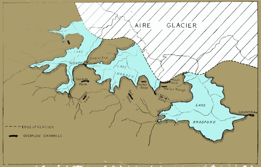
During the short glacial period summers, rivers draining from upland not covered by ice often found their path to lower ground blocked by glacial ice. This resulted in chains of small lakes forming in the upper parts of their valleys. The waters escaped by either flowing over watersheds around the ice margin into neighbouring valleys or under the ice. Good examples of this occur around Bradford (Figure 5) where the Aire glacier ponded up lakes in its tributary valleys, which then overflowed, cutting new channels across hillsides that are now dry, which are known as glacial meltwater channels.

Figure 5 – Glacial lakes and overflow channels around Bradford
River courses and valleys in lowland areas were modified even though they were not covered by ice. Ice in the North Sea blocked the outlets of the district’s drainage via the Humber and a large ice mass filled much of the Vale of York, Together, these created a large lake, known as Lake Humber, which occupied the rest of the Vales of York and Trent. The lake flooded the lower valleys of the River Calder as far as Horbury and the Aire as far as Kirkstall (Leeds) resulting in the deposition of sands, silts and muds. It is through these deposits that the lower courses of the modern-day rivers are cut. At Wetherby, the river course was blocked by ice and moraine of the Vale of York glacier and a lake formed whose waters overflowed a low part of the Permian limestone ridge, cutting the gorge like section which the Wharfe still flows through today.
